The link of those island :
1.www.seychelles.com
2.www.visitmaldives.com
3.www.tahiti-tourisme.com/islands/borabora/
4.www.hamptons.com
5.www.hawaii.com
6.www.nantucket.net
7.www.seefraserisland.com
8.www.st-barths.com
9.www.langkawi.com.my
10.www.hawaiiweb.com
Saturday, 22 June 2013
1..Seychelles


One
of the most photographed beaches in the world, the pale pink sands of Anse
Source d’Argent unfurls across the island of La Digue, one of the 115
components of this archipelago in the Indian Ocean. The sands sparkle against a
backdrop of towering granite boulders, worn by time and weather. The turquoise
water is relatively shallow and protected from the ocean’s waves by a reef.
Seychelles' 115 islands fall under two distinct
groups. The tall granite, Inner Islands cluster mainly within the relatively
shallow Seychelles' plateau, 4° south of the equator and roughly 1800 km.
distant from the east coast of Africa while the low-lying coralline cays,
atolls and reef islands of the Outer Islands lie mainly beyond the plateau up
to 10° south of the equator.
These Outer Islands are divided into five groups: the Amirantes group lying 230km distant from Mahé, the Southern Coral Group, Alphonse Group, Farquhar Group and finally the Aldabra Group, some 1150km from Mahé. There are 43 Inner Islands in all -- 41 granitic and 2 coralline and a total of 72 coralline Outer Islands.
These Outer Islands are divided into five groups: the Amirantes group lying 230km distant from Mahé, the Southern Coral Group, Alphonse Group, Farquhar Group and finally the Aldabra Group, some 1150km from Mahé. There are 43 Inner Islands in all -- 41 granitic and 2 coralline and a total of 72 coralline Outer Islands.
History
Scholars assume that Austronesian seafarers and later Maldivian and Arab traders were the
first to visit the uninhabited Seychelles. Remains of Maldivian mariner
presence from the 12th century were found in Silhouette
Island. The earliest recorded sighting by Europeans took place
in 1502 by the Portuguese Admiral Vasco da Gama,
who passed through the Amirantes and named them after himself (islands of the
Admiral). A transit point for trade between Africa and Asia, the islands were
occasionally used by pirates until the French began to take control starting
in 1756 when a Stone of Possession was laid by Captain Nicholas Morphey. The
islands were named after Jean Moreau de Séchelles, Louis XV's
Minister of Finance. The British contested control over the islands between
1794 and 1810. Jean Baptiste Quéau de Quincy, French administrator of
Seychelles during the years of war with the United Kingdom, declined to resist
when armed enemy warships arrived. Instead, he successfully negotiated the
status of capitulation to Britain which gave the settlers a privileged position
of neutrality. Britain eventually assumed full control upon the surrender of Mauritius in
1810, formalised in 1814 at the Treaty of Paris. Seychelles became acrown colony separate
from Mauritius in 1903. Elections were held in 1966 and 1970. Independence was
granted in 1976 as a republic within theCommonwealth. In 1977, a coup d'état
ousted the first president of the republic, James Mancham,
who was replaced by France Albert René.
The 1979 constitution declared a socialist one-party state, which lasted
until 1991. The first draft of a new constitution failed to receive the
requisite 60% of voters in 1992, but an amended version was approved in 1993. In
January 2013, the country declared a state of emergency; the tropical cyclone
Felleng caused torrential rain, and flooding and landslides destroyed hundred
of houses.


2..Maldives


The Maldives or Maldive Islands,
officially Republic of Maldives, is an island nation in the Indian Ocean formed
by a double chain of twenty-six atolls stretching in a north-south direction
off India's Lakshadweep islands, between Minicoy Island and Chagos Archipelago.
It stands in the Laccadive Sea, about seven hundred kilometers (435 mi)
south-west of Sri Lanka and (250 mi) south-west of India.
Welcome to the beautiful island of
Maldives, where sands are white as the smiles of the locals, where fish swim
happily in the warm waters of the Indian Ocean, where the weather is a dream,
and the deep rays of the sun wait to engulf you their arms.
Although the Maldives are known the
world over for the stunning beaches and azure waters that typify the tropical
idyll, its life beneath the water's surface is becoming ever more respected by
divers in the know.
Maldives is a beautiful
island,accessible for all types of bugets.Here u can find a numerous
hotels,luxury villas and budget accommodation.
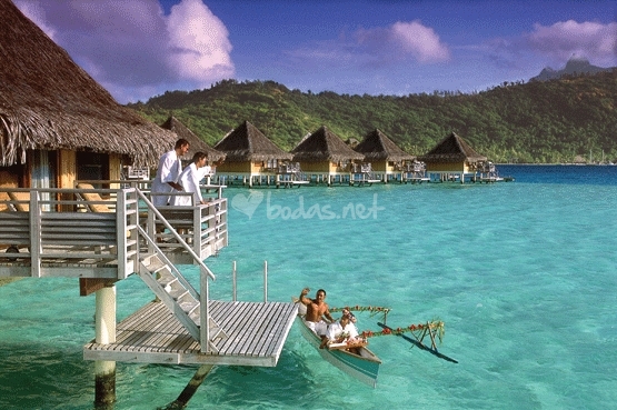
3..Bora Bora, Tahiti

This is one of the magical islands that
make up French Polynesia in the South Pacific. Just 18 miles (29 kilometers)
long, this lush little slip of land lies in a protected lagoon edged by white
sandy shores, the best being at Matira Point. Bora Bora boasts the nickname the
“Romantic Island,” a moniker easy to appreciate with its isolated beaches,
intimate hotels, and quiet atmosphere. French Polynesia more commonly known as
"Tahiti" is located in the South Pacific approximately 8 hours by
plane from the city of Los Angeles. It is in the same timezone as Hawaii, and
the same distance south of the equator as Hawaii is north.
History
Queen Teriimaevarua III and her maids
of honor, c. 1899
The island was first inhabited by
Polynesian settlers around the 4th century AD. The first European sighting was
made by Jakob Roggeveen in 1722. James Cook sighted the island in 1770 and
landed that same year. The London Missionary Society arrived in 1820 and
founded a Protestant church in 1890. Bora Bora was an independent kingdom until
1888 when its last queen Teriimaevarua III was forced to abdicate by the French
who annexed the island as a colony.
Commune of Bora Bora
The commune of Bora-Bora is made up of
the island of Bora Bora proper with its surrounding islets emerging from the
coral reef, 29.3 km² (11.3 sq mi) in total, and of the atoll of Tupai (11 km2
or 4.2 sq mi), located 20 kilometres (12 mi) north of Bora Bora. The atoll of
Tupai has no permanent population apart from some workers in the coconut
plantations.
The surrounding islets include: Motu
Tapu, Motu Ahuna, Tevairoa, Motu Tane, Motu Mute, Motu Tufari, Motu Pitiaau,
Sofitel Motu, Motu Toopua and Toopuaiti.
The commune is in the administrative
subdivision of the Leeward Islands and divided into three districts: Vaitape,
Faanui and Anau.


4..The Hamptons, New York


The Hamptons
are a group of villages and hamlets in the townships of Southampton and East
Hampton, which form the South Fork of Long Island, New York. The Hamptons form
a popular seaside resort, one of the historical summer colonies of the American
Northeast. They have some of the most expensive residential properties in the
U.S.
The Montauk
Branch of the Long Island Rail Road, the Montauk Highway, and the Hampton
Jitney connect the Hamptons to the rest of Long Island and to New York City,
while ferries provide connections to Shelter Island, New York and Connecticut.
Long Island's
Hamptons region has long been the summer playground of the rich and famous. It
consists of a string of always chic seaside communities where today's most
well-known celebrities own summer homes. Visitors often flock here hoping to
see the stars in Southampton, East Hampton, Bridgehampton and the other
communities along the South Fork.
And while here, don't forget to visit the beachside community at Montauk.Long
Island musicians, artists, actors and other creative people have always found
inspiration here. But the spectacular beaches, fine restaurants, first-rate
shopping, and historic sites also make it a popular destination for those
interested in more than just famous people from New York. The area is replete
with enchanting Bed and Breakfasts, local inns and hotels that make it the
ideal spot for a getaway at any time of the year.
5..Lanikai Beach, Hawaii

Half a mile of sparkling sand,
palm trees swaying over a white beach, lush tropical plants, and endless
sunshine make Lanikai one of Hawaii’s most scenic beaches. The shore is
protected by a nearby coral reef, which keeps the surf relatively calm. The
water is always deep green and postcard-perfect.
Lanikai is also known as
"heavenly sea". I remember back to the 1980's when Lanikai Beach was
bigger with much more sand. Rumor has it that storms moved a lot of sand north
around the point to Kailua Beach. However, I seem to recall Kailua Beach
previously having more sand also.
This is a classic, beautiful beach, but it is small. The descriptions of soft, white powder sand and calm turquoise waters are true. This is the favorite beach of a lot of people. What makes many Hawaiian beaches so special are the offshore islands you can see from many beaches. Here you can see Na Mokulua (meaning, in Hawaiian, "the two islands"). They are also commonly known as "The Moks" (rhymes with "smokes") or the "Twin Islands". The larger island (on the left/north) is Moku Nui and the smaller, Moku Iki. They are part of the Hawaii State Seabird Sanctuary.
Lanikai does not have a parking lot, so parking is limited in the residential area. Do not park in the bike lane or you will get a ticket. Take note there are no facilities such as a lifeguards, bathroom, shower or change facilities. You need to go to Kailua Beach Park for those. Lanikai has been getting more crowded. I would suggest taking a walk here from Kailua to check it out, taking your pictures and then walking back to Kailua.


6..Nantucket Island, Massachusetts

The
most popular beaches on this island in the North Atlantic are Surfside and
Children’s. The waters here are relatively calm, and there’s plenty of sand to
use for sunbathing or castle-building. Madaket Beach is known for its rougher
surf and not-to-be-missed sunsets. Quidnet Beach provides great views of
Sankaty Head lighthouse.
History
Nantucket's
settlement by the English did not begin in earnest until 1659, when Thomas
Mayhew sold his interest to a group of investors, led by Tristram Coffin,
"for the sum of thirty Pounds...and also two beaver hats, one for myself,
and one for my wife". The "nine original porchasers" were
Tristram Coffin, Peter Coffin, Thomas Macy, Christopher Hussey, Richard Swain,
Thomas Barnard, Stephen Greenleafe, John Swain and William Pike. Seamen and
tradesmen began to populate Nantucket, such as Richard Gardner (arrived 1667)
and Capt. John Gardner (arrived 1672), sons of Thomas Gardner (planter).
In his
1835 history of Nantucket Island, Obed Macy wrote that in the early pre-1672
colony, a whale of the kind called "scragg" entered the harbor and
was pursued and killed by the settlers This event started the Nantucket whaling
industry. A. B. Van Deinse points out that the "scrag whale",
described by P. Dudley in 1725 as one of the species hunted by early New
England whalers, was almost certainly the gray whale, which has flourished on
the west coast of North America in modern times with protection from whaling.
Herman
Melville commented on Nantucket's whaling dominance in Moby-Dick, Chapter 14:
"Two thirds of this terraqueous globe are the Nantucketer's. For the sea
is his; he owns it, as Emperors own empires." The Moby-Dick characters
Ahab and Starbuck are both from Nantucket. By 1850, whaling was in decline, as
Nantucket's whaling industry had been surpassed by that of New Bedford. The
island suffered great economic hardships, worsened by the July 13, 1846
"Great Fire" that, fueled by whale oil and lumber, devastated the
main town, burning some 40 acres. The fire left hundreds homeless and
poverty-stricken, and many people left the island. Another contributor to the
decline was the silting up of the harbor, which prevented large whaling ships
from entering and leaving the port. In addition, the development of railroads
made mainland whaling ports, such as New Bedford, more attractive because of
the ease of transshipment of whale oil onto trains, an advantage unavailable to
an island.
Later
history
As a
result of this depopulation, the island was left under-developed and isolated
until the mid-20th century. The isolation kept many of the pre-Civil War
buildings intact and, by the 1950s, enterprising developers began buying up
large sections of the island and restoring them to create an upmarket destination
for wealthy people in the Northeastern United States. This highly controlled
development can be compared to less-regulated development in neighboring
Martha's Vineyard, the development of which served as a model for what the
Nantucket developers wanted to avoid.
In the
1960s, Nantucket and Martha's Vineyard considered seceding from the
Commonwealth of Massachusetts. In 1977, Nantucket and Martha's Vineyard
actually attempted, unsuccessfully, to secede. The secession vote was sparked
by a proposed change to the Massachusetts Constitution that reduced the
islands' representation in the Massachusetts General Court.
 |
| Brant Point Lighthouse |
7..Fraser Island, Australia

Perched on the sunny Queensland coast 161 miles (259 kilometers)
northeast of Brisbane, Fraser Island is the world’s largest sand island and
home to a wonderful beach. This World Heritage Site is an ecologist’s dream,
with 640 square miles (1,664 square kilometers) of unspoiled natural paradise.
Rain forests with 1,000-year-old trees sprout from the sand. Lodgings here
accommodate a wide range of tourists, from the backpacking ecology lover to
pampered resort fans.
There are some photo that i feel that it is special in this island!!


8..St.Barts
One of many islands in
the Caribbean Sea, St. Bart’s stands out with its blend of French chic and
island relaxation. With beautiful secluded beaches, fine French cuisine, and
gracious hotels, this tropical playground is popular with the Jet Set. The 8-mile-long
(13-kilometer-long) island is edged by 20 beaches and small coves for swimmers
and sunbathers, with sparkling water and white sand. This arid, volcanic rock of just eight
square miles is home to an eclectic mix of iguanas, night-blooming cactus, and
fabulous beaches as well as luxury yachts, designer boutiques, and celebrities…
Peopled primarily by descendents of the original French settlers and
transplanted Europeans, this is an island with a strong, independent
personality. Through the vagaries of its history it became a duty-free port and
more recently liberated itself from the administrative yoke of Guadeloupe. It
is certainly the most unusual of the French West Indies islands.
St. Barts island history
Discovered by Columbus in 1493, and named for his brother
Bartolomeo, St. Barths was first settled in 1648 by French colonists from the
nearby island of St. Kitts. This original settlement was not a grand success,
and, in 1651, the island was sold to the Knights of Malta. Five years later, a
raid by angry Carib Indians destroyed the settlement killing all the settlers.
The victim's heads were placed on poles lining Lorient beach to discourage
prowlers. In 1763, the island was settled again, this time by French mariners
from Normandy and Brittany. This colony succeeded. French buccaneers found the
place hospitable, and brightened the economy with vast quantities of plunder
taken from Spanish galleons. Monbars the Exterminator, a famous buccaneer of
noble French descent, reputedly maintained his headquarters in St. Barths. His
treasure is believed to be still hidden among the coves of Anse du Gouverneur,
or buried in the sands of Saline. Gradually the buccaneers became tradesmen,
shopkeepers, fishermen, and small farmers. The island was too small, too rocky,
and too dry to become part of the sugar economy of the larger islands. Except
for a brief military takeover by the British in 1758, St. Barths remained
French until 1784, when it was sold suddenly to Sweden by one of Louis XVI's
ministers in exchange for trading rights in the Swedish port of Gothenburg. As
a free port under Swedish rule, St. Barths served the useful purpose of
providing a trade and supply center for the various factions of the colonial
wars of the 18th century. When a sea captain captured a prize or raided a
settlement, he could sell the booty in St. Barths, and at the same time
resupply his ship. Overflowing warehouses surrounded a harbor packed with ships
from many nations, and a mercantile tradition was established that has lingered
to the present day. This period of prosperity was short-lived, however, as conflicts
ended, and sailing ships were replaced with motor vessels.
France repurchased the island in 1878. The free port status
remained, and does to this day, along with such Swedish mementoes as bits of
architecture, a cemetery, a few street signs, and, of course, the name of the
harbor and capital, Gustavia. In 1946, Martinique and Guadeloupe, including St.
Barths, were given the legal status of a Department of France with the same
privileges and responsibilities as any of the Home Departments. This is analogous
to the Americans conferring statehood upon Hawaii. The citizens were given
French passports, and were expected to pay French taxes, and obey laws
formulated in Paris. A Black baby, a descendant of slaves, born in a thatched
hut beneath swaying palm trees of Guadeloupe, suddenly became just as French as
Cyrano de Bergerac. In 1957, American millionaire David Rockefeller bought a
property: the notoriety of the island quickly grew and its transformation as an
upscale tourist destination was underway. In 1967, Britain cut loose most of
their Caribbean dependencies because they had become a losing proposition, and
were likely to remain so. Sugar is no longer a profitable product, and growing
populations require more and more public services that local revenues cannot
support. During that same year, France increased the amount of money sent to
its islands, and has every year since. During the last twenty years the
resident population of St. Barths has more than doubled. Fewer natives are
leaving, and growing number of outsiders are arriving to make an island home
for themselves, especially from Metropolitan France. In the past, outsiders
came to St. Barths as a refuge. They valued privacy and detachment, and found
differences of culture a welcome barrier to unwanted familiarity. They were
interesting people, often eccentric, and preferred simplicity and meagerness to
the hazards and resources of the wider world. Two local hotels, Eden Rock and
Les Castelets, were designed and built by members of this vanishing breed. Over
the past 10 years, the islands of Saint Barthélemy and Saint Martin engaged in
a process of political evolution that came to fruition on February 2007 with
adoption of a new status, and the new Overseas Collectivity of Saint Barthélemy
was born on July 15, 2007 and its first territorial council was elected. The 19
members elected Bruno Magras as the first president of the island council. Today
most newcomers arrive in search of opportunity, lured by descriptions in the
popular press of a tax-free tropical paradise where well-heeled vacationing
fools shower money on every uplifted palm. Most are doomed to disappointment.
Living in St. Barths is easy; making a living is not, especially for the
non-native.
9..Langkawi,Malaysia

The name “Langkawi” translates
into “the land of one’s wishes,” a welcoming concept that somewhat belies the
island’s historic origins as a reputed refuge for pirates. Langkawi has since
become a modern hideaway for the traveler seeking an escape. If your vacation
wishes extend from uncrowded white sands and clear waters to lush green
forests, you will find yourself content here. Datai Bay, located on Pulau
Langkawi, is a heavenly retreat on the Andaman Sea.
Langkawi, officially known
as Langkawi, the Jewel of Kedah (Malay: Langkawi Permata Kedah) is an
archipelago of 104 islands in the Andaman Sea, some 30 km off the mainland
coast of northwestern Malaysia. The islands are a part of the state of Kedah,
which is adjacent to the Thai border. On July 15, 2008, Sultan Abdul Halim of
Kedah had consented to the change of name to Langkawi Permata Kedah in
conjunction with his Golden Jubilee Celebration. By far the largest of the
islands is the eponymous Pulau Langkawi with a population of some 64,792, the
only other inhabited island being nearby Pulau Tuba. Langkawi is also an
administrative district with the town of Kuah as largest town. Langkawi is a
duty-free island.

History of Langkawi
Langkawi was traditionally
thought to be cursed. However, in 1986 then Prime Minister Mahathir Mohamad
decided to transform it into a tourist resort, helping to plan many of the
islands buildings himself.[3]
PHUKET: In the 1930s, the
Thai government used the Andaman island of Tarutao as a prison to incarcerate
the country’s most undesirable criminals. When the Japanese Imperial Army
brought the Second World War to the footsteps of the kingdom in December of
1941, the Thai government under Field Marshall Phibun Songkram sided with the
invaders against the allied forces (click here for article of Thailand’s
paradisal prison).
To a certain extent Phibun
admired the Japanese and sympathized with their cause. In return for Thailand’s
friendship and cooperation, the Japanese had promised to return Thai
territories that had been seceded to Britain and France during the late 19th
century. When British Malaya fell to the Japanese invaders in 1941, four Malay
states, Terenganu, Kedah, Kelantan and Perlis, which used to be under Thai
dominion, were returned to Thailand as promised by the Japanese.
Most of the information
hereafter is based on a book written by Pongpol Adireksarn, a well-known Thai
politician and author of several novels based on Thai history. Better known
amongst westerners by his pseudonym Paul Adirex, in 1994 Pongpol wrote a book
called The Pirates of Tarutao, based on actual events that happened in the
penal colony during the Second World War.
From 1942 onwards many
allied prisoners of war were imprisoned on Tarutao Island on orders from the
Japanese. Before the war started, food and supplies were regularly shipped to
Tarutao from the mainland to sustain the prisoners and the wardens. When war
broke out the British navy aggressively blockaded the Malay Peninsula, sinking
any ships that dared to deliver supplies to their enemy. As the war dragged on
supplies on Tarutao Island began to diminish. Food and medical rations were
reduced. Prisoners of war, common criminals and wardens, began to starve alike.
The prison system soon began to break down.
During that time there may
have been more than 10,000 inmates detained on Tarutao Island. According to
Pongpol many high profile political prisoners had already been removed from the
island and transferred to Koh Tao in the Gulf of Thailand, for fear that they
may be liberated if the British captured Tarutao.
Out of hunger and
desperation, the remaining prisoners took to begging from boats that carried
supplies past the island. Guards and inmates were on their own fighting for
survival. The number of deaths from starvation and malaria continued to grow
day by day.
As the situation continued
to worsen and it became clear that simply begging from passing boats was not
going to sustain them for long, several inmates banded together and turned to
piracy. Initially the inmates attacked boats in order to steal food and medical
supplies.
But when it became
apparent that the naval powers were too busy fighting each other to safeguard
the high seas, the pirates became more audacious and violent. Many more inmates
and even prison guards took to piracy. Soon they began to attack ships
indiscriminately, stealing all the cargo that the vessels carried. The
prolonged war had carved out a huge black market for goods that were in short
supply all over the region. As they attacked the passing vessels, the pirates
would plunder them of their valuable cargo. Often they would murder the
passengers and crews. The boats were then set on fire and sunk to the depths of
the sea.
The beautiful landscape of
the island; coasts, estuaries, creeks, rivers and narrow channels served to
conceal the deadly marauders. According to reports from passing vessels,
travellers soon began to fear for their own safety when passing the archipelago
as vicious rumors of pirate attacks began to spread throughout the region.
Ships that traveled between Penang, Satun and Kantang were vulnerable when they
came close enough to Tarutao Island. The pirates also began setting up land
bases on Langkawi Island, just south of Tarutao, using motorboats as well as
sailboats to intercept merchant vessels.
The war in the Pacific
ended in September 1945. After Japan surrendered to the allies, peace returned
to the high seas and blockades were lifted as Malaya and Singapore returned to
British rule. During this time several merchants in Penang began to lodge
complaints with the British Navy about the unabated piracy problem in the
Andaman Sea.
Between December 1945 and
March 1946, the British Navy launched a large-scale operation to clear the
Strait of Malacca of its pirate infestation. At first the British simply used
patrol boats to accompany merchant ships along the trade route. But they soon
began to actively intercept pirates on the high seas and engage them. British
efforts soon drove the pirates back to their bases on Tarutao and Langkawi
Islands. In March 1946 the Thai and British navies conducted a joint operation
and raided the penal colony of Tarutao.
According to Pongpol,
three warships and over 300 troops stormed Tarutao Island in order to arrest
the inmates and prison guards that were suspected of piracy during the war
years. The raid turned violent and many pirates died in the ensuing fight.
When the joint
British-Thai forces managed to secure the island again, order was restored and
the inmates were returned to their former prison conditions. A new prison
governor was also appointed to manage the prison. The penal colony would
survive for another year or so.
In 1947, the Tarutao penal
colony was formally closed down. For decades after that the island would remain
deserted. The thick tropical forest soon grew to assimilate the prison
facilities, the cells, the offices and the kitchens. It would be years before
backpackers would venture out to find Tarutao Island again, and put it on the
tourist map. By then most of the physical evidence of its horrific past had
been erased by nature, leaving behind a clean slate to start over for what
would become a very different future for Tarutao Island.
10 activity
that u can do in here
1. Visit Dataran Lang
Dataran Lang which means
‘Eagle Square’ epitomizes the very significance of Langkawi. Here is where you
can see and enjoy the monumental 12-meter sea eagle ready to take flight on a
square located within Kuah Town. It is just beside the Kuah Jetty which means
that if you are coming to Langkawi Island through the ferry service, the
gigantic eagle is the first to ‘welcome’ you. Around here, you will also be
able to take photos of the surrounding ponds, bridges and others. From here,
you will also be able to go around the retail shops and outlets where you will
be able to enjoy some duty-free shopping.
2. Find out the stories of
Mahsuri’s Tomb
Located at Padang
Matsirat, the Mahsuri’s Tomb is perhaps the most illustrious place to visit as
the legend of Mahsuri is very much synonymous with Langkawi Island. Here, you
will find a complex that very much narrates the story and holds the shrine of
Mahsuri whose story goes that she was wrongly accused for committing adultery
and was subsequently sentenced to death. It was told that white blood poured
out of her body that signified her innocence where she then cursed the island
for 7 generations before her death. This is where you can get a pictorial
understanding of the story and make your own judgements on whether the stories
are true or merely legends.
3. Visit the Underwater World
Langkawi
The Underwater World
Langkawi in Pantai Cenang is perhaps one of the best places to go if you are
visiting Langkawi Island with your family. A great place for the children and
everyone, it is an award winning complex where you can be ‘close’ up with the
many types of fishes and sea life around here. There are more than 100
specially designed tanks that offer the almost natural habitat for the over 500
species of sea creatures respectively. On top of that, there is also an
underwater tunnel tank which you will be wandering through a 15 meters, 6
million liter water tank which will be a truly unique and unforgettable
experience.
4. Learn about Galleria
Perdana
The Galleria Perdana is
located in Pantai Kok where it is essentially the place that houses and
exhibits all the gifts and presents which have been presented to Tun Dr
Mahathir Mohamad, the former and longest serving prime minister of Malaysia.
The museum is where you will find some of the most interesting mementos and
memorabilia offered to Dr Mahathir when he was in office which will give you a
clear picture of the political accomplishments of the country throughout
history especially on the bilateral ties with other countries.
5. Experience the Cable
Car & Skybridge
This is where you will
enjoy the spectacular sights and sounds of Langkawi Island through a bird’s eye
view elevated from the ground. The Cable Car will take you through about 15
minutes to the peak of Mount Machinchang in the island. Throughout the ride,
you will be able to experience some of the most beautiful sights of the island
and its rich vegetation around. To take the ride, you will have to get your
tickets at the Oriental Village and then when you reach the peak, you can take
the amazing suspension Skybridge which will accord you with yet another
elevated experience.
6. Visit Lagenda Langkawi
Dalam Taman
The Lagenda Langkawi Dalam
Taman is a theme park which is located in Kuah Town just next to the main
jetty. Here is where you will be able to appreciate the rich folklore of
Langkawi Island which essentially is an open air garden museum. It houses
several statues and sculptures of the legends and folklore of the island that
will allow you to see for yourselves how the likes of the mythical birds and
beautiful princesses of the stories look like. You will also be able to
appreciate the beauty of the gardens here while taking a walk along the gardens
in its vicinity.
7. Take the Sunset Dinner
Cruise
A luxurious and truly
unforgettable experience when visiting Langkawi Island is to take the Sunset
Dinner Cruise. There are better ways to see the waters and enjoy the sunset
then through the Jacuzzi-style cruise as well as enjoying great food on a boat.
Here is where you can take in the spectacular and amazing sights of the island
while drinking cocktail at the bar of the boat that swerves through the
pristine waters of Langkawi Island and the surrounding Andaman Sea.
8. Take a tour into Sungai
Kilim Nature Park
One of the best places you
can go to enjoy the nature and sights of Langkawi is to head out to Sungai
Kilim Nature Park which essentially is a protected mangrove swamp area. Here is
where you can find some of the most beautiful sceneries of the mangrove forests
as well as inhabited beaches and lagoons. There is thousands of flora and fauna
that you will be able to enjoy as you work your way up the river banks while
you can also bask in the sights of the rich vegetation along the tour or just
appreciate the quietness and peace of the surroundings.
9. Mingle with wildlife at
the Langkawi Bird Paradise And Wildlife Park
The Langkawi Bird Paradise
is the first fully covered wildlife park in Asia and it is where you will be
able to see and experience some of the most beautiful wildlife sceneries in
Langkawi Island. There are more than 2,500 birds here like eagles, canaries,
hornbills and such, all of which come from the 150 species roaming around here.
Inside the park, you will also be able to visit a man-made waterfall and as the
park is covered, you can visit the Langkawi Bird Paradise and Wildlife Park at
any time of the day during its operational hours.
10. Visit the Al-Hana
Mosque
Located within the busy
town of Kuah, the Al-Hana Mosque is one of the architectural wonders in
Langkawi Island. Here is where you can find some of the most interesting motifs
and designs which are topped with a golden dome on top inspired through the
Moorish culture. Despite being in the town centre, it offers a place of peace
and tranquillity where Muslims come and worship and say their prayers. The
Al-Hana Mosque is also known for exuding some of the most beautiful
Uzbekistan-inspired carvings.
 |
| 4 season resort I'm proud to be a citizen of Malaysia becuz when i notice that Langkawi beaches is also one of the beaches in the top 10 list ^^ |
Saturday, 15 June 2013
10..Kauna'oa Bay,Hawaii
Let's show u guys more information abt the beaches><
Kauna'oa Bay, Hawaii

Located on the Kohala Coast of the Aloha-state's Big Island, Kauna'oa Bay is quintessential, picture-postcard Hawaii. With its abundant white sand, palm trees and clear, calm blue water, the crescent-shaped beach is a natural draw for sun worshipers, water sport enthusiasts and families in search of safe, sandy fun.
 History of the beach

The land above the bay is part of the Parker Ranch. In 1960
the area was a remote, barren, hot lava field unsuitable for cattle grazing.
William F. Quinn, the governor of the new state of Hawaii, invited Laurance
Rockefeller to visit the islands as part of a study for a federal commission
that Rockefeller chaired. After visiting the ranch, Rockefeller was taken for a
swim in the bay. Plans for a resort began in January 1961. The state agreed to
pave theHawaii Belt Road (called the Queen Kaʻahumanu highway for this section)
to the site and build a new Kona International Airport. Rockefeller bought the
land of the nearby Puʻukoholā Heiau and donated it for a National Historic
Park. Original plans were to use architect John Carl Warnecke and build a
series of small cottages, but those plans were abandoned. Instead firm
Skidmore, Owings and Merrill was hired to use a modern style.
The open-air design allowed natural ventilation from the
trade winds, although rooms had air conditioning available. The hotel finally
opened in July 1965, one of the most expensive at the time. Hotels with similar
designs would be built along the Kohala coast over the next decades. Ranch
owner Richard Smart negotiated a long term lease of the land. The hotel was
named Mauna Kea Beach Hotel for the mountain Mauna Kea which is visible above
the bay when not obscured by clouds.
spaces were made available starting in 1981, and trails opened up along the
shoreline.
spaces were made available starting in 1981, and trails opened up along the shoreline.

WHERE TO STAY??
Best on the Beach
Westin Mauna Kea Beach Resort
Web: princeresortshawaii.com/mauna-kea-resort-hawaii.php
Westin Mauna Kea Beach Resort
Web: princeresortshawaii.com/mauna-kea-resort-hawaii.php
If there's one strip of sand on the Big Island that rivals Kauna'oa Bay, it's Hapuna Beach and the Hapuna Beach Prince Hotel, nestled in the cliffs above. The resort, with its 350 guest rooms, including 36 suites, shares 1,839 acres with its sister property, the Mauna Kea Beach Hotel.
The area takes its name from underground springs that once created natural artesian fountains - called hapuna, or spring of life. The resort stays close to its roots, pledging to offer an environment where travelers can rejuvenate. Guests here also have full privileges at the Westin Mauna Kea, just a short walk or free bus ride away.
Best Family Hotel
Hilton Waikoloa Village
Web: www.hiltonwaikoloavillage.com
The locals call Hilton Waikoloa Village Disneyland and, like the land of Mickey, it hits the mark with kid-friendly features - a monorail, an acre of swimming pools, a lazy river, a man-made beach and a four-acre lagoon complete with dolphins. The resort's 1,240 guestrooms and suites are divided among three low-rise towers. Seven restaurants serve up Japanese, Chinese and Italian as well as steak, seafood, snacks and even organic dishes. Guests can also enjoy privileges at 2 golf courses, 8 tennis courts, 6 bars and an 18-hole executive putting course.
Best Hideaway
Kona Village Resort
Web: www.konavillage.com
With 125 individual cottages, Kona Village offers an escape from the modern world, without doing away with luxuries expected from a trip to paradise. There are no en suite telephones, TVs or radios and guests stay in individual, thatched roof cottages strewn across 82 acres of seaside property. Of course, you will never be far from the modern world and all of its diversions - pools, restaurants, bars, tennis, sailing, kayaking, snorkeling, volleyball, a glass-bottom boat and petroglyph tours are all available. Located about 15 miles south of Kauna'oa Bay, this resort also offers access to black-sand and white-sand beaches located nearby.
 Food & Drink

Best Waterfront Atmosphere
Kamuela Provision Company
Web: www.hiltonwaikoloavillage.com
The popular Kamuela Provision Company at the Hilton Waikoloa Village serves up a stunning view of the Pacific along with creative Pacific fusion cuisine that takes full advantage of the sea's bounty as well as local gardens. The atmosphere is causal but the entrees are upscale. Sit inside or if it's whale season, ask to be seated in the lanai dining area, which offers some of the best whale watching in the resort. The restaurant is also home to the resort's only wine bar, with more than 40 labels offered by the glass.
Excellent Local Seafood
Cafe Pesto
Web: www.cafepesto.com
With plenty of fresh local seafood, and a curious combination of Italian and Asian inspiration, Cafe Pesto is a tasty alternative to the local resorts. Set in the tiny harbor town of Kawaihae, the Cafe began as a take-out pizzeria and quickly became associated with regional cuisine. Take your pick of culinary delights - from the fresh catch of the day, to wok-fired shrimp and scallops to Pacific island seafood risotto and, of course, hand-tossed pizzas with creative toppings.
Best Family Restaurant
Lu'au, Westin Mauna Kea Beach Resort
Web: www.maunakeabeachhotel.com/
It might seem hokey, but for family fun Hawaiian style, a lu'au is a must. Every Tuesday at 5:30 p.m. on the oceanside lu'au grounds of the Westin Mauna Kea Beach Hotel, resort staff open the emu pit - an underground oven where a pig has been roasting for most of the day. The pig is removed, prepared and then served up as part of a traditional Hawaiian buffet. Join the feast and relax while local hula dancers entertain to the tune of ancient and modern Hawaiian music.
We can have some activity such as....
Best Kid Stuff
Parker Ranch
Web: www.parkerranch.com
It may come as a surprise to most visitors - and their kids - that the 50th state is home to the nation's largest privately owned cattle ranch. Sprawled between the Mauna Kea and Mauna Loa volcanoes, the 225,000-acre Parker Ranch surrounds the town of Waimea and Kamuela. It produces 10 million pounds of beef each year, and its paniolos, or cowboys, work nearly 400 horses and more than 50,000 cattle. During the summer, there are even rodeos. The ranch also offers tours, wagon rides, historic homes and plenty of dining options - believe it or not, there's more than just beef.
Best Day Trip
Hawaii Volcanoes National Park
Web: www.nps.gov/havo/
Home to both the world's most massive volcano, Mauna Loa, and the world's most active volcano, Kilauea, Hawaii Volcanoes National Park may be the Big Island's biggest attraction. The park's 218,000 acres range from sea level to a dizzying 13,677 feet at the peak of Mauna Loa. Kilauea's ongoing volcanic activity, meanwhile, continues to add mass to the Big Island, spewing molten lava that slowly increases the island's base. Hiking trails abound, as do cautions about the area's fragile ecosystem. The park has been named an International Biosphere Reserve as well as a World Heritage Site and more than half of its acres have been designated wilderness.
Best Site Seeing
Helicopter Tours
The Big Island, although not the most populated of the Hawaiian islands, is the largest, so there is plenty of ground to cover. And the best views of the island's diverse terrain can be seen from the air. Helicopter operators close to the Kohala Coast include: Sunshine Helicopters: 808-882-1223;www.sunshinehelicopters.com
Best Stargazing
Mauna Kea Observatories Support Services
Web: www.ifa.hawaii.edu/info/vis
At 14,000 feet, Mauna Kea offers of one the island's best vantage points for exploring the sky. Each evening the Mauna Kea Observatory Visitor Information Station, located at 9,300 feet above sea level, hosts a stargazing program. The road to the visitor's center is paved and children are encouraged to visit, but to get higher into the mountain a 4-wheel drive vehicle is needed. Traveling the unpaved road to the summit is arduous and visitors must provide their own 4-wheel-drive transportation. In addition to its sky view, Mauna Kea also offers another rare Hawaiian treat - skiing. There are no lifts or ropes, but for those who want to race down a snow-covered mountain before they head back to the beach, there is no better bet.
Here is some information abt the beach...hope that it come benefits to u all^^
Subscribe to:
Comments (Atom)