The link of those island :
1.www.seychelles.com
2.www.visitmaldives.com
3.www.tahiti-tourisme.com/islands/borabora/
4.www.hamptons.com
5.www.hawaii.com
6.www.nantucket.net
7.www.seefraserisland.com
8.www.st-barths.com
9.www.langkawi.com.my
10.www.hawaiiweb.com
Saturday, 22 June 2013
1..Seychelles


One
of the most photographed beaches in the world, the pale pink sands of Anse
Source d’Argent unfurls across the island of La Digue, one of the 115
components of this archipelago in the Indian Ocean. The sands sparkle against a
backdrop of towering granite boulders, worn by time and weather. The turquoise
water is relatively shallow and protected from the ocean’s waves by a reef.
Seychelles' 115 islands fall under two distinct
groups. The tall granite, Inner Islands cluster mainly within the relatively
shallow Seychelles' plateau, 4° south of the equator and roughly 1800 km.
distant from the east coast of Africa while the low-lying coralline cays,
atolls and reef islands of the Outer Islands lie mainly beyond the plateau up
to 10° south of the equator.
These Outer Islands are divided into five groups: the Amirantes group lying 230km distant from Mahé, the Southern Coral Group, Alphonse Group, Farquhar Group and finally the Aldabra Group, some 1150km from Mahé. There are 43 Inner Islands in all -- 41 granitic and 2 coralline and a total of 72 coralline Outer Islands.
These Outer Islands are divided into five groups: the Amirantes group lying 230km distant from Mahé, the Southern Coral Group, Alphonse Group, Farquhar Group and finally the Aldabra Group, some 1150km from Mahé. There are 43 Inner Islands in all -- 41 granitic and 2 coralline and a total of 72 coralline Outer Islands.
History
Scholars assume that Austronesian seafarers and later Maldivian and Arab traders were the
first to visit the uninhabited Seychelles. Remains of Maldivian mariner
presence from the 12th century were found in Silhouette
Island. The earliest recorded sighting by Europeans took place
in 1502 by the Portuguese Admiral Vasco da Gama,
who passed through the Amirantes and named them after himself (islands of the
Admiral). A transit point for trade between Africa and Asia, the islands were
occasionally used by pirates until the French began to take control starting
in 1756 when a Stone of Possession was laid by Captain Nicholas Morphey. The
islands were named after Jean Moreau de Séchelles, Louis XV's
Minister of Finance. The British contested control over the islands between
1794 and 1810. Jean Baptiste Quéau de Quincy, French administrator of
Seychelles during the years of war with the United Kingdom, declined to resist
when armed enemy warships arrived. Instead, he successfully negotiated the
status of capitulation to Britain which gave the settlers a privileged position
of neutrality. Britain eventually assumed full control upon the surrender of Mauritius in
1810, formalised in 1814 at the Treaty of Paris. Seychelles became acrown colony separate
from Mauritius in 1903. Elections were held in 1966 and 1970. Independence was
granted in 1976 as a republic within theCommonwealth. In 1977, a coup d'état
ousted the first president of the republic, James Mancham,
who was replaced by France Albert René.
The 1979 constitution declared a socialist one-party state, which lasted
until 1991. The first draft of a new constitution failed to receive the
requisite 60% of voters in 1992, but an amended version was approved in 1993. In
January 2013, the country declared a state of emergency; the tropical cyclone
Felleng caused torrential rain, and flooding and landslides destroyed hundred
of houses.


2..Maldives


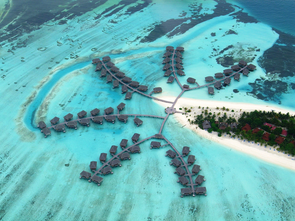


The Maldives or Maldive Islands,
officially Republic of Maldives, is an island nation in the Indian Ocean formed
by a double chain of twenty-six atolls stretching in a north-south direction
off India's Lakshadweep islands, between Minicoy Island and Chagos Archipelago.
It stands in the Laccadive Sea, about seven hundred kilometers (435 mi)
south-west of Sri Lanka and (250 mi) south-west of India.
Welcome to the beautiful island of
Maldives, where sands are white as the smiles of the locals, where fish swim
happily in the warm waters of the Indian Ocean, where the weather is a dream,
and the deep rays of the sun wait to engulf you their arms.
Although the Maldives are known the
world over for the stunning beaches and azure waters that typify the tropical
idyll, its life beneath the water's surface is becoming ever more respected by
divers in the know.
Maldives is a beautiful
island,accessible for all types of bugets.Here u can find a numerous
hotels,luxury villas and budget accommodation.
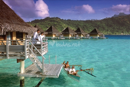
3..Bora Bora, Tahiti

This is one of the magical islands that
make up French Polynesia in the South Pacific. Just 18 miles (29 kilometers)
long, this lush little slip of land lies in a protected lagoon edged by white
sandy shores, the best being at Matira Point. Bora Bora boasts the nickname the
“Romantic Island,” a moniker easy to appreciate with its isolated beaches,
intimate hotels, and quiet atmosphere. French Polynesia more commonly known as
"Tahiti" is located in the South Pacific approximately 8 hours by
plane from the city of Los Angeles. It is in the same timezone as Hawaii, and
the same distance south of the equator as Hawaii is north.
History
Queen Teriimaevarua III and her maids
of honor, c. 1899
The island was first inhabited by
Polynesian settlers around the 4th century AD. The first European sighting was
made by Jakob Roggeveen in 1722. James Cook sighted the island in 1770 and
landed that same year. The London Missionary Society arrived in 1820 and
founded a Protestant church in 1890. Bora Bora was an independent kingdom until
1888 when its last queen Teriimaevarua III was forced to abdicate by the French
who annexed the island as a colony.
Commune of Bora Bora
The commune of Bora-Bora is made up of
the island of Bora Bora proper with its surrounding islets emerging from the
coral reef, 29.3 km² (11.3 sq mi) in total, and of the atoll of Tupai (11 km2
or 4.2 sq mi), located 20 kilometres (12 mi) north of Bora Bora. The atoll of
Tupai has no permanent population apart from some workers in the coconut
plantations.
The surrounding islets include: Motu
Tapu, Motu Ahuna, Tevairoa, Motu Tane, Motu Mute, Motu Tufari, Motu Pitiaau,
Sofitel Motu, Motu Toopua and Toopuaiti.
The commune is in the administrative
subdivision of the Leeward Islands and divided into three districts: Vaitape,
Faanui and Anau.


4..The Hamptons, New York


The Hamptons
are a group of villages and hamlets in the townships of Southampton and East
Hampton, which form the South Fork of Long Island, New York. The Hamptons form
a popular seaside resort, one of the historical summer colonies of the American
Northeast. They have some of the most expensive residential properties in the
U.S.
The Montauk
Branch of the Long Island Rail Road, the Montauk Highway, and the Hampton
Jitney connect the Hamptons to the rest of Long Island and to New York City,
while ferries provide connections to Shelter Island, New York and Connecticut.
Long Island's
Hamptons region has long been the summer playground of the rich and famous. It
consists of a string of always chic seaside communities where today's most
well-known celebrities own summer homes. Visitors often flock here hoping to
see the stars in Southampton, East Hampton, Bridgehampton and the other
communities along the South Fork.
And while here, don't forget to visit the beachside community at Montauk.Long
Island musicians, artists, actors and other creative people have always found
inspiration here. But the spectacular beaches, fine restaurants, first-rate
shopping, and historic sites also make it a popular destination for those
interested in more than just famous people from New York. The area is replete
with enchanting Bed and Breakfasts, local inns and hotels that make it the
ideal spot for a getaway at any time of the year.
5..Lanikai Beach, Hawaii

Half a mile of sparkling sand,
palm trees swaying over a white beach, lush tropical plants, and endless
sunshine make Lanikai one of Hawaii’s most scenic beaches. The shore is
protected by a nearby coral reef, which keeps the surf relatively calm. The
water is always deep green and postcard-perfect.
Lanikai is also known as
"heavenly sea". I remember back to the 1980's when Lanikai Beach was
bigger with much more sand. Rumor has it that storms moved a lot of sand north
around the point to Kailua Beach. However, I seem to recall Kailua Beach
previously having more sand also.
This is a classic, beautiful beach, but it is small. The descriptions of soft, white powder sand and calm turquoise waters are true. This is the favorite beach of a lot of people. What makes many Hawaiian beaches so special are the offshore islands you can see from many beaches. Here you can see Na Mokulua (meaning, in Hawaiian, "the two islands"). They are also commonly known as "The Moks" (rhymes with "smokes") or the "Twin Islands". The larger island (on the left/north) is Moku Nui and the smaller, Moku Iki. They are part of the Hawaii State Seabird Sanctuary.
Lanikai does not have a parking lot, so parking is limited in the residential area. Do not park in the bike lane or you will get a ticket. Take note there are no facilities such as a lifeguards, bathroom, shower or change facilities. You need to go to Kailua Beach Park for those. Lanikai has been getting more crowded. I would suggest taking a walk here from Kailua to check it out, taking your pictures and then walking back to Kailua.


6..Nantucket Island, Massachusetts

The
most popular beaches on this island in the North Atlantic are Surfside and
Children’s. The waters here are relatively calm, and there’s plenty of sand to
use for sunbathing or castle-building. Madaket Beach is known for its rougher
surf and not-to-be-missed sunsets. Quidnet Beach provides great views of
Sankaty Head lighthouse.
History
Nantucket's
settlement by the English did not begin in earnest until 1659, when Thomas
Mayhew sold his interest to a group of investors, led by Tristram Coffin,
"for the sum of thirty Pounds...and also two beaver hats, one for myself,
and one for my wife". The "nine original porchasers" were
Tristram Coffin, Peter Coffin, Thomas Macy, Christopher Hussey, Richard Swain,
Thomas Barnard, Stephen Greenleafe, John Swain and William Pike. Seamen and
tradesmen began to populate Nantucket, such as Richard Gardner (arrived 1667)
and Capt. John Gardner (arrived 1672), sons of Thomas Gardner (planter).
In his
1835 history of Nantucket Island, Obed Macy wrote that in the early pre-1672
colony, a whale of the kind called "scragg" entered the harbor and
was pursued and killed by the settlers This event started the Nantucket whaling
industry. A. B. Van Deinse points out that the "scrag whale",
described by P. Dudley in 1725 as one of the species hunted by early New
England whalers, was almost certainly the gray whale, which has flourished on
the west coast of North America in modern times with protection from whaling.
Herman
Melville commented on Nantucket's whaling dominance in Moby-Dick, Chapter 14:
"Two thirds of this terraqueous globe are the Nantucketer's. For the sea
is his; he owns it, as Emperors own empires." The Moby-Dick characters
Ahab and Starbuck are both from Nantucket. By 1850, whaling was in decline, as
Nantucket's whaling industry had been surpassed by that of New Bedford. The
island suffered great economic hardships, worsened by the July 13, 1846
"Great Fire" that, fueled by whale oil and lumber, devastated the
main town, burning some 40 acres. The fire left hundreds homeless and
poverty-stricken, and many people left the island. Another contributor to the
decline was the silting up of the harbor, which prevented large whaling ships
from entering and leaving the port. In addition, the development of railroads
made mainland whaling ports, such as New Bedford, more attractive because of
the ease of transshipment of whale oil onto trains, an advantage unavailable to
an island.
Later
history
As a
result of this depopulation, the island was left under-developed and isolated
until the mid-20th century. The isolation kept many of the pre-Civil War
buildings intact and, by the 1950s, enterprising developers began buying up
large sections of the island and restoring them to create an upmarket destination
for wealthy people in the Northeastern United States. This highly controlled
development can be compared to less-regulated development in neighboring
Martha's Vineyard, the development of which served as a model for what the
Nantucket developers wanted to avoid.
In the
1960s, Nantucket and Martha's Vineyard considered seceding from the
Commonwealth of Massachusetts. In 1977, Nantucket and Martha's Vineyard
actually attempted, unsuccessfully, to secede. The secession vote was sparked
by a proposed change to the Massachusetts Constitution that reduced the
islands' representation in the Massachusetts General Court.
 |
| Brant Point Lighthouse |
Subscribe to:
Posts (Atom)